 Filter: Categories of Wisconsin Historical Images
Filter: FORMAT_DIMENSIONS of 55 x 53 cm.
Filter: Categories of Wisconsin Historical Images
Filter: FORMAT_DIMENSIONS of 55 x 53 cm.

| Date: | 1849 |
|---|---|
| Description: | Published a year after Wisconsin entered statehood, this map shows the counties and towns in existence at the time - mainly in southern/southeastern Wiscon... |
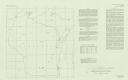
| Date: | 1980 |
|---|---|
| Description: | This map shows earthquake data and includes text about tables, references, and the Modified Mercalli Intensity Scale of 1931. Table one lists earthquakes c... |

| Date: | 1975 |
|---|---|
| Description: | This map provides an index of quadrangle maps for the state. The lower left corner contains explanation land surveying completeness. Communities, counties,... |

| Date: | 1975 |
|---|---|
| Description: | This map provides an index of outdated quadrangle maps for the state. Communities, counties, rivers, and lakes are labeled including Lake Michigan and Lake... |
If you didn't find the material you searched for, our Library Reference Staff can help.
Call our reference desk at 608-264-6535 or email us at: